 wolfgangloeffler – weitgereist
Laber and Ettaler Mandl

Really outstanding mountain panorama with a view of the Zugspitze awaits you during this tour. Sure, there is a road in the valley that connects Oberammergau and Ettal but this would mean that you miss the great views of the surrounding mountains. To reach the summit of the Ettaler Mandl you will have to climb a bit but the route is secured with wire rope and even beginners can do this. I really enjoyed it. At the top of the Laberbergbahn you will find a restaurant where you will not only get great food but also a breathtaking view. The tour is not too strenuous since the ascent is not that steep. What are you waiting for?
differnce in height: 3,150 ft. in the ascent, 3,000 ft. in the descent
walking time: 5h 50 min.
Our winter was rather mild but in March in it came with full force. Especially over the Easter weekend there was heavy snowfall in the mountains. So I had to wait until the end of April before I was able to go on my first hike. To open the season I chose a tour that was not really heavy duty but still gave great panoramic views.
At 7:30 a.m. I am standing at Munichs main station and want to board the train that’ll bring me to Oberammergau. Unfortunately the rail tracks were barred due to an accident and I was told to take the suburban train to Pasing where there will be a bus shuttle service bringing me to Tutzing. When I arrived in Pasing I was looking for the bus but couldn’t find it. So I go to the information desk, wondering if there is already someone that early in the morning. I am lucky in 2 senses. There is somebody and the lady tells me that the suspension is finished and I can get the train I originally planned to go on. 2 hours later I am in Oberammergau.


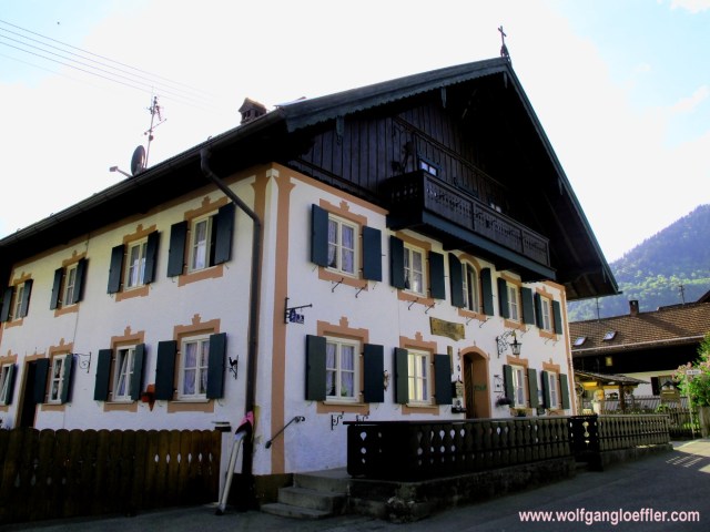
As a kid I have been there already once. A lot of people have heard of the famous passion play (sorry there is no englisch site) showing the last days of Jesus. The first time it was shown in 1634 and since 1680 they do play it every 10 years (the next date will be 2020). Reason for the play was a promise given when the plague was ravaging the village. The actors are the locals living in ths village. Oberammergau is also known for the murals called „Lüftlmalerei“. They do exist the all over the region but nowhere in such an concentration. With a small detour you can look at these works of art. Or you just enjoy the slide show below. Some of the pictures date from a second visit, hence the clouds.
It’s really pretty to look at but I am not sure if I would come here just because of it. So when you are in the region go visit the village.
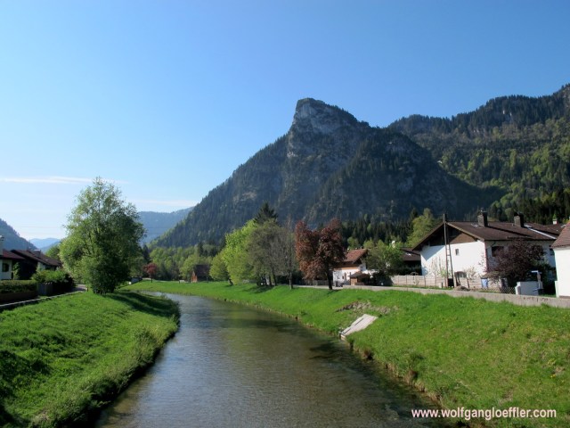
But now it’s time for the mountain. At first you have to cross town . Along St.-Lukas street you follow the signs leading to the open air bath WellenBerg which is very nice and the valley station of the Laberberg cabin. From the train station to the cabin you walk about 1,5 miles. A good leg to warm up.
After a while the road leads to a trail that follows the river „Ammer“. You are still in the middle of town but it is definetly getting more quiet here.


Three weeks ago this was still covered with a good amount of snow. A few days with sunshine and springlike temperatures have changed the scenery and everything is green and in full bloom. That’s what I like about spring when mother nature is coming to life again.
Large trees are offering shade while I continue to walk along the creek and I now see those beautiful meadows shining in a bright yellow.


Soon I reach the WellenBerg. Through the fencing I can see the lawn and the still empty basins. Looks very nice and clean. I think it would be great to come back and spend a day swimming here.
The valley station of the cabin is only a few steps away now. Just this small waterfall and the chapel hidden in the woods are separating me from it.


Here I have to cross the parking lot and look for the sign leading me to the summit of the Laber. That’s easy to find and so I can start the ascent. A few quick shots of the snow covered summits around and off I go.


Crossing a meadow the path leads uphill. Soon I get a great view of the mountains and the beautiful scenery around me. At the moment there are only a few other hikers around. That’ll change later on. Especially on the summit I will meet other hikers and excursionists that didn’t want to walk up the mountain.


At the edge of the forest and on the meadow I can marvel at the first spring flowers. The yellow flower on the top right is a wild primrose the ancestor of the ones you can see in many gardens in the spring time. When I was a kid we used to collect large bouquets and bring them home. They have a nice and decent scent. You can pick the flowers, but taking the roots is prohibited.
A few minutes later I reach a forest road. Here I have to decide wether I want to continue via the Soilasee, a small lake, or take the route leading me across the Schartenköpfe, a ridge leading to the summit of the Laber. The sign towards the Schartenköpfe has a note saying only for experienced hikers. As long as you are not afraid of heights and sure-footed you can ignore it. This is the trail with the greater views.


When you are on that path that you see above you will come along a watering hole and then see a rock sitting in the meadow. I only recognized at the second sight that I will have to take a left here and follow the path into the woods. From time to time you see the gondolas of the cabin flying over your head but most of the time you rather just hear them.


Soon the path runs uphill along a forest aisle and with every foot I gain in height I get a more spectacular view of Oberammergau and the valley. On this path there aren’t many people. Did they get scared by the sign „for experienced hikers only“? I do enjoy the fresh spring air and continue uphill.


At the Laberberg alp I reach the next crossing. Here I can go back down to that lake or continue my way to the summit. On the hillside in front of me I can see signs that have been used for the skiers during the winter. And I am standing in front of the first of quite a few snow fields I will have to cross during the rest of my ascent.


From time to time I see holes in the snow where fellow hikers before me did sink in all the way to their knees. I am lucky and can always find foot prints that allow me to cross those fields without getting wet. There is still a lot of snow around and at some points it is rather difficult to see where the path continues.
The closer I get to the summit of the Schartenkopf the rockier the mountain above becomes. Don’t worry this is not the part where you will have to climb,yet.


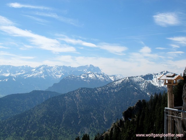
A few steps berfore reaching this summit the scenery opens up in the southwestern direction and I get a great view of the Zugspitze. It’s not too far away and when we’re talking about Germany’s highest mountain it’s pretty clear that it has to dominate the region.
I finally do reach the summit of the Schartenkopf. From here on you will have to be sure footed and not afraid of heights. It’s name means head of the notches and to it’s sides you have steep cliffs falling down. But it offers a breathtaking panoramic view.


To the north you overlook the valley of the Ammer and the alpine upland. To the south Kloster Ettal is at your feet and behind the mountain range called Wetterstein with the Zugspitze at it’s western end. These are the moments when I realize why am doing such crazy hikes with the ordeal of the ascent. It is such an uplifting feeling on top of those mountains. I allow myself a few minutes to take in this great view.
The path to the moutain station of the gondolas leads along a small ridge but is easy to walk. Sometimes it is bordered by mountain pine sometimes by spruce which means that you will have loop holes to enjoy the panorama.


All of a sudden you will get a first glimpes of the 2 fingers forming the summit of the Ettaler Mandl. Even when you have reached the highest point of your tour when you reach the mountain station you will not find a cross. It is just the highest point of the ridge that I just have crossed.
Finally comes the second best moment of every tour. I am standing on the terrace of the restaurant at the end of the mountain gondola Laberbergbahn with a really breathtaking view. In the far you see the Wetterstein mountains and a sumit called Kramer in front. Somewhere in between the two is Garmisch-Partenkirchen.
I have earned a hearty lunch now. The first non-alcoholic beer fizzles down my throat and the salad made of sausage and cheese arrives in no time. It is presented very nicely and the serving would actually be enough for 2 meals. I have a long descent in front of me so I can burn off all those calories again.
As beautiful as it is here, at one point I do have to continue. There is one more summit waiting for me.


Right next to the restaurant I take a few more shots of the northern view into the alpine upland and off I go. The Ettaler Mandl sits on a lower elevation so I continue downhill. After a few steps I can finally see that small lake I have read about earlier on those signs.


On this side of the mountain the path leads too along some cliffs through the forest. Since I am now walking on the southern side of the mountain the snow is gone. I was fearing that the rocky summit of the Ettaler Mandl will be too slippery and wet to climb but it was dry.
Along the path I come across a few more spring flowers. Like this february daphne. Please do not touch it if yu see one. It is highly poisonous.


On my way to the summit of the Ettaler Mandl I do meet quite a few fellow hikers. I’m wondering what to expect there. And there it is. About 15 people are here with me. Among them a father with his young son just finishing to get buckled up with their climbing gear. I can certainly understand that the boy is wearing this for safety reasons. The rest of the people in front of me are just discussing which is the best fitting equipment. This takes a bit too long for my taste and I decide – somewhat impolite yes – to jump the queue and use an alternative entry into the rock wall.


It looks worse than it actually is. I am no experienced climber by far but since the ascent is secured with ropes I can easily climb this rock. Without any snap hooks and straps around my legs. As a matter of fact it is great fun. Maybe I should start climbing?
And soon I have reached the summit.

The view is fantastic. To the south I can see the Wetterstein mountains, to th east I can see across the valley of the Loisach to the Hoher Fricken and Wank. And to the North I see the alpine upland and the Staffelsee.


Since there are quite a few people in line coming up the summit, I can’t enjoy this view as long as I would have wanted to and so I soon begin the descent. There is only one „lane“ so I have to take a few breaks to let the people pass.
After reaching the foot of the rock I follow the signs towards Kloster Ettal.


The path leads through forest which is more dense at some points and less at others. Along the path I can marvel at more spring flowers. Then I reach a point where the path has cut a deep gap into the forest floor.
Every once in a while I can catch a glimpse of Kloster Ettal between the branches.


After around 1.5 hours of a rather leisurely descent I reach the valley floor and the monastery of Ettal. But before I visit this architectural jewel I want to check when the next bus for Oberau ist leaving.


I found the bus stop quickly. As per timetable there is a bus leaving in ten minutes and the next one in 45. So I decide to take the second one and go for a drink. That’s refreshing. I have some time left to explore the monastery and go for a stroll.


This baroque monastery in the middle of the mountains is very beautiful. I am deeply impressed and decide to come back to take a closer look. But now it’s time to catch the bus.
Back at the bus stop I have to realize that I haven’t read the timetable correctly and that I was looking at the operating hours during the week. On saturdays the next bus comes another 45 minutes later. Too bad. Due to no connection I can’t go on the internet. Meanwhile I am somewaht tired and don’t want to go on exploring. So I take a seat and wait.
When I finally reach the train station in Oberau, I have to realize that I will have to wait another hour before the next train departs. So I am looking for a supermarket or a gas station where I can buy something to drink. Bad luck, there is no such thing in this village.
So this great tour has an unexpected and not so great ending and when I finlly board the train direction Munich I am not in the best mood. But not too long, cause looking back at this eventful day in such great scenery and nature calms me down quickly.
I hope you liked this post and am looking forward to reading your comments.


Kommentare