 wolfgangloeffler – weitgereist
Hike to the Wilde Kreuzspitze

The Wilde Kreuzspitze is a summit with approx. 10,300 ft at the end of the Vals valley in South Tyrol close to the Austrian border. While preparig this trip this was the only hike that was described in guide books. I was tantalised already for quite some time to stand on a mountain with more than 10,000 ft. The ascent is not too strenuous but above 8,0000 ft. it could be that you encounter difficulties due to the thin air. The only part that is really steep ist the stretch between the Rauhtaljoch (9,100 ft.) and the summit. Unfortunately we couldn’t go all the way up since the weather changed dramatically and a strong wind blew snow clouds in from Austria. Curios how it went? Then read on.
Great Services for hikers
The hotel Falkensteiner Hof includes in its rates the Almencard Plus which gives you the right to use several mountain gondolas for free. But it does include even more services, such as a weekly hiking program with guided tours. For my third day in Vals they offered a guided tour to the Wilde Kreuzspitze. Since I had this tour on my bucket list I registered and did my first tour with guide. I wasn’t sure what to expect during this hike and if I am in good enough shape. It was a somewhat reassuring feeling to know that there is someone in case of an emergency.
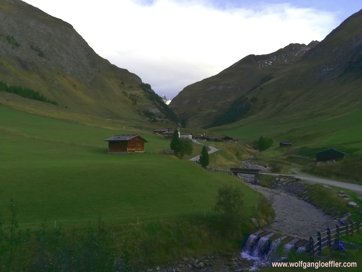


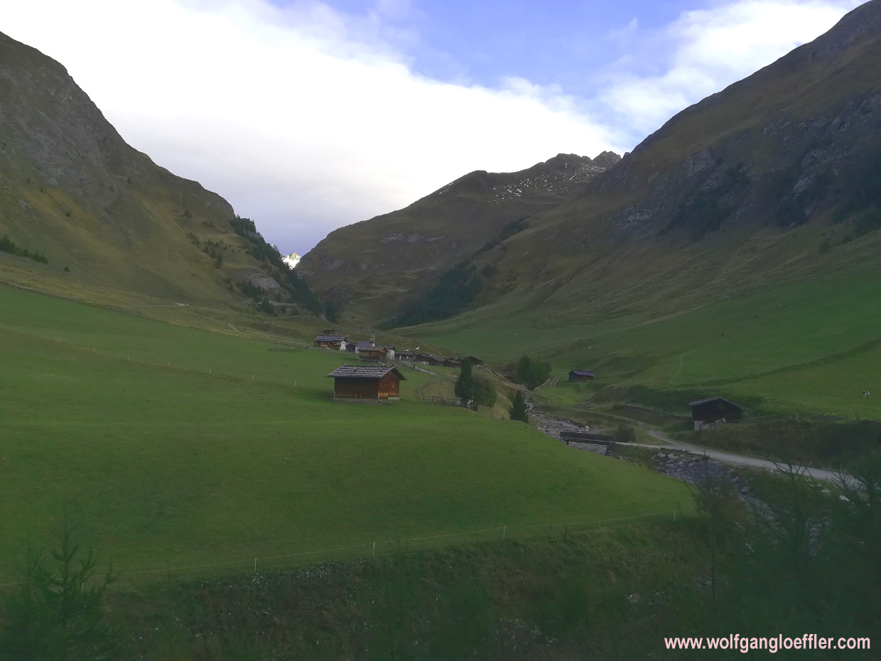
The Fane Alm, a quaint alp village
The starting point of this tour is at the Fane Alm on 5.700 ft. The alp village sits idyllicaly in a high valley. In the past the farmers of Vals spent their summers up here. The green valley did offer food for the cattle and they were able to crop hay for the winter. On top they were able to make cheese and butter from the milk right on the spot. This saved them the long daily ascent and they had their families around them. In the evenings they entertained themselves with dance and games. Every wednesday before bringing back the animals to the valley in the fall the farmers still put on bells at nightfall in order to celebrate the parting from the pastures with chimes and cracks of whips.
Fane Alm
The village is still being used by the farmers. In some of the rustic cabins you will find restaurants offering typical south tyrolian specialties. Such a landmark doesn’t stay a secret and so there are quite a few people scrimmaging around here in summer. Thank God not in such numbers as at the Engalm in the Karwendel mountains. Large coaches can’t drive up here, yet.
When we arrive a strong wind with a northernly direction is blowing and it is pretty fresh. So early in the morning the village lies still calm and deserted. This makes it even quainter. Behind the alp the trail mounts steeply. Our guide tells us that he plans to reach the summit by noon.


We quickly leave the Fane Alm behind and walk on the next level of this terrace like valley. To the south in the far we have a view of the summits of the Geisler group. From time to time fields of clouds are moving over us. As long as it stays dry, no problem. To our left and right the summits of the Pfunderer mountains are towering above us. Very impressive. I kind of like it to walk in a small group. It seems that we are on the same condition level and are making good progress. We are walking a long a forest road and the tour is quite easy to hike so far.


Crossing the Schramme Canyon
A short time after we reach a canyon with a creek running through. Every once in a while we do see small waterfalls from our trail way above the creek. Just as to expect the wind blows even stonger here and I have to take my cap off. Well, I don’t think I will be needing sun shade today. Most of the time it is partially cloudy. The alpine scenery up here is amazing.


Not far from the end of the canyon we come across a sign in rememberance of the ‚decent vrigin‘ who at the age of 19 fell into the canyon and died in 1926. Poor girl. These days the trail is well groomed and to the side there is a rail making sure that such things won’t happen again so fast.


Soon after we leave the canyon and reach another valley. If we would continue straight uphill we would soon reach the Brixener Hütte. But we take a left turn and walk direction Labesebenalm. The road leads through the shade of the Schattenseite (meaning something like shadow side). The incline is still not too bad and I am wondering how we can make the 4,600 ft. in ascent when it’s not getting steeper. There is still a cold wind blowing but from time to time we do get some sun now.


While we are continuing we talk about the tours we already made. One of the guys has a Spanish wife and already did some hiking in the Pyrenées. This is one of th regions where I would love to go hiking. I already found quite a few hikes along the French-Spanish border that I would love to make. For now it’s South Tyrol, though. Half an hour later we do reach the next high valley and see the Labesebenalm. That means that we completed the first 1,300 ft.


On the oppsite side we get a view of the Wurmaulspitze which is just like the Wilde Kreuzspitze covered with snow. Up to now we didn’t cross any snow but we certainly will in higher elevations. Two days ago it has been snowing heavily up here. The scenery is beautiful. It probably is even more in early summer when the pastures are in full bloom.


Labeseben, a secluded alp
After reaching the alp we take a short break. There are still some 3,300 ft. lying ahead of us. Up to know most of my tours ended at around 7,000 ft. I am curious to see how I will be manging the rest of the tour. Mostly how I will cope with the thinner air further up the mountain. Our guide reassures us and says that we will just run out of steam a bit quicker.


Behind the alp the path mounts slowly along the side of the mountain. We are now ticking off the rise in elevation faster but it’s not too steep and is easy to manage. The next break is planned at the Wilde See. To the right we can already see the flow from the lake that has cut a deep line into the rock. To our left we now see the summit of the Kalkgrubenspitz. In between there is a ridge wich we are crossing to reach the lake.


Here at almost 8,000 ft. we come across the first fields of snow. On the pasture we see dried up stems of dead flowers. The guide asks us if we know what this is and is quite impressed when I can tell him right away that this was yellow gentian. Out of the roots of this plant you can make schnaps. We are asking us why you always see the blue gentian on the labels which is not in that liquor. I would assume it’s the blue colour that makes it more appealing than the yellow.


The ‚Wilde See‘ lake
And then we reach the ridge that is separating us from the lake. We get our first clear view of the summit we want to climb. We are told by our guide that this is the biggest lake in an alpine surrounding in the alps. There are fish in the lake and during summer you will see people angling here. The fish won’t find cleaner water anywhere. But I am asking myself how they survive the long and cold winters up here.


To circle the lake there are two possibilities. The easier way leads along the western shore to your left. The other path runs along the east side but apparently has a short descent and then a steep ascent at the end. We take a left and come across small snow fields that are quite deep at times due to drifts. That was something we did expect when we started the hike. At least it’s not a closed cover of snow we have to wade through.


Behind the lake sitting on 8,300 ft. the path rises a bit steeper over a mixture of grass and rubble towards the Rauhtaljoch. Our guide tells that we will realise why it’s called (rau meaning coarse) Rauhtaljoch soon. Just a moment later the wind is picking up and grows into a storm which makes the ascent more difficult. Along with the storm clouds are moving in and it starts to snow slightly. The snowflakes feel like ice pickets and it’s becoming uncomfortably. The summit vanishes more and more often in clouds.


Storm and snow at the Rauhtaljoch
At the Rauhtaljoch (9,200 ft.) we take a break and discuss if we should continue. We would have the time to climb the summit. Would I have been alone, I would have done it. To give up such a short time before the goal is not my thing. I wanted to be on this summit so badly. One of the guys hiking with us says that in case we continue he’ll be waiting here at the joch for us. The guide looks at us and considers what to do. In the end he says that he thinks it’s too dangerous to go on. From the north the clouds are getting thicker and the storm is blowing as strong as ever. Unfortunately I am not in a position to tell the guys to walk on and climb the summit on my own. Wasn’t meant to be. So I am accepting the vote and we start to descent.


Over rubble we walk downwards into the Rauhtal. On this side of the ridge nothing is growing. We see a glacier alomost completely covered by rubble. The wind still blows heavily and we have to fight against it to move forward. After a short steep stretch we continue on more even ground. The high valley we are crossing now is like a caldera sourrounded by impressive rock walls. Very beautiful.


With every foot we move away from the summit it is getting sunnier. Should we have done the summit? When looking back we do see that the summit is still hidden in the clouds. As if along the Austrian border would run a wall keeping the clouds there. I decide to come back and then walk all the way up. Now that I know that I can do it.


Panoramic views at the Brixener Hütte
On this side too the descent is not to strenuous. We have less snow around now and the sunshine is getting brighter. And the strong wind we faced on the Rauhtaljoch is calming down. We walk comfortably with the wind in our back and soon reach the Brixener Hütte.


This cabin sits on 7,500 ft. on a hill. From here you get a great view into the Dolomites. We look for a lee side table and are sitting down to enjoy the sun. Of course our guide knows the landlady and so we start talking. We are asking about the stuffed groundhog and she tells us that in spring those animals are roaming the terrace and even enter the cabin. Apparently they give up their timidity. Hunger is stronger and so those small animals are becoming courageous. Before we leave the landlady offers us a homemade schnaps made of herbs. You can’t buy it. It is reserved for special guests. What a luck that our guide is one of them.


Crossing a pasture we keep walking downhill. A short stretch is a bit steeper but easily to walk on the forest road. Soon we reach the Pfannalm. Meanwhile it is mostly sunny and the temperature is rising a bit. I can open my jacket. Today I am certainly not sweating.


Following the valley of the Valser creek we continue in direction of the Fane Alm where we started. In the far we can now see the summits of the Geisler group. But say for yourself, isn’t that an amazing view? A few minutes later we reach the crossing where took a left to the Labesebenalm this morning. From here we walk on the road we came up this morning.


Again we cross the canyon. In the afternoon sunlight it looks a bit friendlier. What a bummer that we had such bad weather at the summit. But the tour was well worth the while even without the summit. The next time I will try to come in spring. I want to see the pastures in bloom and the groundhogs at the Brixener Hütte.


Another 30 minutes later we are back at the Fane Alm where we started this morning. Again a great mountain tour comes to its end. It was awesome even without the summit cross.
During the summer months a shuttle runs from the Kurzkofelhütte to this alp. Privately owned cars don’t have the right to acces then. If you don’t want to drive along the small and steep road up to the Fane Alm you can take a hiking path leaving from the Kurzkofelhütte which is called Milchsteig. But this adds another 1,000 ft. to your ascent.
I hope you like my post and am lookoing forward to your comments. If you like what you just read, don’t hesitate to share it.


Kommentare