 wolfgangloeffler – weitgereist
Höllentalklamm and Kreuzeck

During this diversified tour you will first discover a spectacular canyon, where you will encounter a lot of people at times. In the further course breathtaking views of the Kramer mountain, the Zugspitze and towards the end the Ester and Karwendel mountains await you. If you are afraid of heights you might want to take the alternate route that I will be describing later in this post. On the stretch between the Höllental and Kreuzeck you will come across a few spots where the path is secured with wired rope. During this tour you pass a few cabins where you can take a rest. Sounds interesting? Then continue reading. Enjoy!
difference in altitude : approx. 3,250 ft. in the ascent, approx. 3,445 in the descent
walking time: approx. 7 hours
It is the end of June and I’ve got a few days off. The weather forecast has great weather in store, so I don’t reflect very long and take the train to Garmisch-Partenkirchen. The Höllentallklamm has been sitting on my bucket list for quite some time already and I do hope that there aren’t too many people on this trail on a weekday.
Once I have reached Garmisch-Partenkirchen I have to change from the Deutsche Bahn to the Zugspitzbahn. That’s very easy since the two train stations are next to each other. When you are travelling with the Bayernticket, you won’t need to buy a new ticket, since the Bayernticket is valid until Hammersbach, where you will leave the train and start the tour.


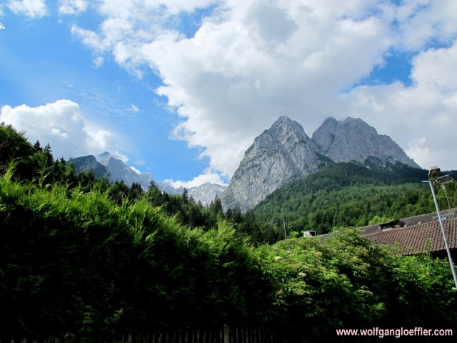
From the train station you already have a great first view of the summits of the Wetterstein mountains. A few white clouds are building a nice contrast to the blue of the sky. This will be another great day. There are quite a few people waiting for the train. Most of them will probably visit the Zugspitze. They just opened the new spectacular gondola. The trains of the Zugspitzbahn, though, are right from the museum and don’t have air-condition. Despite the fresh temperatures outside it is already pretty warm inside the train. Fortunately the ride to Hammersbach doesn’t take too long.


At the Hammersbach station I follow the tracks in the driving direction of the train for a moment until I reach the creek that has the same name as the village. It’s a small village and there is not much to see here. The creek has a lot of water, which is due to the heavy thunderstorms of the past days. This raises the anticipation for the canyon, since there will be quite some water swooshing through its narrows.
The road leads along the creek and mounts very slowly into the valley. Since I am walking through a forest that offers a great deal of shade it’s very comfortable. I did bring sun screen but at the moment it is not necessary.


The many rapids in the creek do offer great motives for pictures. In front of me there is a bunch of American college students wearing their typical sandals on their feet. I have to tell you that this is not the appropriate footwear. But it’s them who have to walk in them. There are a lot more people around. Just like I assumed. The Höllentalklamm isn’t exactly what you’d call a hidden secret but a worldwide known nature sight out of the ordinary.


After about 30 minutes I do get a first glimpse towards the valley through which the canyon runs. To the left I have a view of the Osterfeldkopf, sitting in front of the Alpspitze. Meanwhile the trail rises a bit steeper along a forest road, but it still is rather easy to walk. This fresh, crisp air and the panorama are just wonderful. It is really beautiful here.


The trail didn’t follow the creek for a while but is now bringing me back to it. This means I have a few more chances to take a few great shots. The valley is getting narrower and to the right as well as to the left the rock walls are climbing into the sky. And finally I see the first water fall of today. So I was right and the thunderstorms filled them with water.


Soon I do reach a point from where I have a great view back into the valley and of the Kramer sitting across the valley. I did cross this mountain last year. You can read the post of this tour here.
After about an hour I reach the cabin that marks the entrance to the Höllentalklamm. This cabin is in operation and looks rather cozy, but it is too early for a break for me. There will be one further up the mountain where I plan to have a light lunch.


This canyon opened to the public about 100 years ago. It was built by the waters of the Hammersbach which shaped the spongy rock over millions of years. At some points it is up to 500 ft deep. It is very tight and even in summer it is rather fresh and you have to count on getting wet. So make sure to take a light raincoat on this tour. And sturdy shoes are a must. The floor can be very slippery.


To walk through this canyon you will have to pay 5€ per person. That’s money I am happy to spend since this makes sure that the trail is well kept. During the winter the bridges and racks are being taken down. The danger that they might be missing after the snow has melted is just too big.


The name translates as „valley of the hell“. But it probably derives from the German word Höhle, meaning cave. And a cave you will see further up the mountain. The path has been hewn out ouf the rock by men. In the 19th century there was a lead mine on top of the canyon. So they needed a path leading to this mine. During WWI they also extracted molybdenum, but already in 1925 the mine has been closed due to not being profitable.


Right after you enter the canyon it get’s spectacuar. Through a very tight spot the water ist pressing into a waterfall rushing down into the valley. Soon after you reach a tunnel. The path through the canyon is about 2/3 of a mile long and rises 410 ft. Everywhere it dripps from the walls and I start getting wet. But I couldn’t care less.


It took 4 years until the path through the canyon was completed. It was officially opened on Aug. 15th in 1905. That must have beeen pretty hard work. All those rocks that had to been moved out of the way. Back then they didn’t have the machines that would have made this task easier. If you want to have more info about the canyon you can turn to the website Homepage which is unfortunately only available in German.
At one tight point there is this huge snow ball blocking the way. Would be interesting to know how long it will take before it’s completely molten. I have to admit that sometimes it does make sense to visit a tourist attraction. This canyon is awesome. Fascinating what an artist water can be.


At the end of the canyon the valley opens up again and you can see the ruins of the mine. You will also see tunnels from the mine but do not enter them, since there is a great danger of them collapsing. Unfortunately the sky has covered with clouds and it is overcast now. Guess I won’t be taking pictures of the Zugspitze today. Despite it being rather close. Walking through this canyon is part of the ascent to the Zugspitze, if you are ready to do it in 2 days.


And then there is the cave that gave this valley its name. At least I guess so. In the meadows of the valley I do find all those pretty flowers like this orchid. The valley opens up even more and is very green. After a short ascent I continue on a rather flat stretch in an alpine valley. In front of me at the end of the valley I can see this wall of rock. Without the clouds I should be able to see the Zugspitze from here.


Luscious green on the valley floor and steeply mounting rock walls to the left and the right, this a very dramatic setting. And all those beautiful flowers. Awesome.


The path leads along the creek that is running in rapids towards the canyon. This is again one of those moments where I do feel a great sense of contentement. What could be more beautiful?


Fascinating this huge snow field where a waterfall has been digging a tunnel through it. On the homepage of the canyon I read that there can be as much as up to 230 ft. of snow accumulated in winter. The valley is narrow and the high mountains around keep the sunlight out. That’s why this trail is being closed in winter.


At the end of the valley I first see this small chapel. A great motive for nice shots. Across from this chapel ist the Höllentalangerhütte. The old cabin had to be torn down in 2014. The new ones has been built avalanche safe and is very nice. The perfect place for a snack in a dramatic surrounding.


Actually I had planned just as it was described in my tour guide book to take the Stangensteig back to Hammersbach. But it’s only 1 p.m. and the descent would only take 2 hours.
In front of the cabin there is a sign showing additional trails in the area. One of them leads over the Hupfleitenjoch to the Kreuzeck. Walking time: 1.5 hours. Sounds like a perfect prolongation of my tour. From the Kreuzeck I can tak the gondola back into the valley or descent all the way down to Partenkirchen. Freshly restored I continue.


The narrow path nestles up against the rock wall and to the left the rock is falling steeply into the valley. I gain height pretty fast and soon have fascinating views of the Waxenstein and the waterfall on the other side of the valley. Despite the clouds this is a great tour and I do enjoy this day.


After a while the view into the Garmisch valley and the mountains surrounding it opens up further. And on this side of the moutain there are a lot of alpine roses in full bloom. Sometimes it is referred to these flowers as the alp booze. All those pinkish red dots between the green of the pastures are just great.


I come across this small canyon. A small wooden bridge without rail leads over the creek. On this trail there are less people as on my way up through the canyon. To my right is probably the Alpspitze hidden in the clouds. In the far I do see a few houses sitting on a ledge. Can’t be the usual alp cabins, the terrain around the is too steep and overgrown.


Finally I do reach the Knappenhäuser. These houses were built for the miners. During my research concerning those houses I found an article from 2010 where they offered these houses along with around 495 acres of land for a million Euro. That’s what I call a bargain. Especially in the light of knowing that everything has to be carried up here. There is no road leading up here and I couldn’t find out if there is electricity. But you can’t get closer to mother nature.
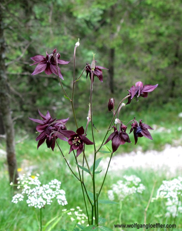
I rather admire this exceptionally beautiful columbine. I have never seen one with such dark flowers.
From those houses it is not far any more to the Hupfleitenjoch with 5,755 ft the highest point of this tour. Above my head I can see the scenic platform they have built a few years ago on the Alpspitze. As with other platforms of this type the kick is the feeling of standing high above a valley on a glass floor, giving you the impression of flying. The detour to this platform would take too long though.


So I enjoy a last view of the Höllental, the Knappenhäuser and the Waxenstein before I descend into a trough. Above my head passes a cabin of the Alpspitz gondola. In theory I could turn right and climb to the mountain station of this gondola. But since the path to the Kreuzeck gondola runs downhill, I opt for the latter.


While crossing the trough on the Hupfleite I recognize all those yellow dots in the green meadow. At the end of it I do get a great view of Garmisch-Partenkirchen way down in the valley. I do enjoy this beauty. The city and daily routine is so far away up here.


Once again I have to climb a short stretch and am happy that it is the last for today. After reaching the ridge I now have a great panoramic view into the Karwendel and a few feet below another cabin. I guess I’ll have a cool drink down there.


Since I am not quite sure anymore into which direction to contunie I do ask the waitress at the Hochalm what is faster: Taking the descent to Hammersbach or rather descend into Partenkirchen straight away. To my surprise she tells me that in both directions it’ll take me about 4h. Looks like I’ll have to take the gondola on my way down. It is 3 p.m. and I still have a 1.5h train ride in front of me.


From the Hochalm it is just a few minutes to the Kreuzeck gondola. The road leads past this porous rock wall. One of these days it’ll tumble down. I was just getting used tot he idea that I will ride the gondola into the valley when I come across this sign showing me a trail to Partenkirchen in 2.5 hours. Sooooo if it ’s not taking 4 hours……. Hell, I can still take the gondola when I am old ……….


At first I have to walk to the Kreuzeckalm and leave this inviting bench on the left. I think this bench does look into the wrong direction. When you sit down on it you will have the great panorama in your back. Makes no sense. Just before reaching the Kreuzhütte there are new signs. I can’t find the sign showing towards Tonihütte which is the trail I want to walk. But since I have seen the Trögelhütte on the first sign I decide to take this trail and hope it’s the right one.


The path is easy to walk and doesn’t go down too steeply. Soon I do reach the Trögelhütte which is not operational and realize that I am now standing in the middle of the skiing slopes. Where in the winter time skiers are racing downwards are now gracing cattle.


The clouds are diminishing by now and I get great views of the summits around me. The Zugspitze apparently thinks today that I have taken enough shots of it already and keeps hiding behind the clouds. When I come across this cow above I can’t keep myself from asking which coiffeur she has been to. This tuft is just a bit too accurate.


The trail continues in a slow descend towards the valley and is very good to walk. Every once in a while it leads through dense forest but then again through open terrain offering great views.


Meanwhile even the sun comes out from time to time and the bees are not only enjoying the nectar but also the heat. And then there is another cabin in the middle of the woods. But not the Tonihütte. I will later realize that it is not really a cabin, but a farmhouse and not a cute one. On the gras next to the farm there is a group of young kids taking part in some sort of olympic games.


After the Tonihütte I walk along a forest road for a while and finally come to a crossing. There are no signs and so I have to guesse where I will continue. I decide to take the road that is leading downhill. And soon afterwards I see the sign towards Riessersee. That’s where I want to go.


The path to the lake takes me alongside the historical bobsled run which has been used until the 1960s. On the picture it looks llike just another hiking trail but if you are standing in front of it you can make out the embankments on which they did build the ice walls.
I thought I read somewhere that it takes only 15 minutes from Riessersee to the train station in Partenkirchen. That’s not quite true. It takes forever. First the path descends down to the valley floor which you will reach at a railway crossing. From there you will continue on a tarred bike/pedestrian trail leading along the tracks. That’s where the train passed this morning bringing me to Hammersbach. The last stretch of the tour is the „worst“. I am already rather tired and want to board my train to Munich but the way to the station is stretching into eternity. And especially here.


I am crossing just another waterfall and always have a view of Garmisch and the Kramer mountain. On the bottom of the Kramer I even can make out the blue umbrellas of the St.Martin cabin, where you will get the best blueberry pancakes on this planet. Got to put this one back on my bucket list. When I finally reach the train station the sun is shining. So I made a 7 hour hike out of a 4.5 hour tour. Pretty tired but very happy and content I am riding home.
I hope yu did like my 101st post despite it being a bit longer than usual. Looking forward to your comments.


Kommentare